
. (2022), Tehran 35°41'11.68\"N, 51°23'24.18\"E. Optical layer, Maxar Technologies; CNES/Airbus. [Online] Available at: http://www.google.com/earth/index.html [Accessed 29 April 2022].")
How can groundwater extraction lead to land surface subsidence?
Land surface subsidence can occur due to groundwater pumping from compressible sediments (Gambolati & Teatini, 2015). The total geostatic load on the aquifer and confining beds is balanced in part by the pore pressure within the sediment. When groundwater is extracted from aquifers by pumping wells, the static water level in the aquifer goes down and pore pressure declines. The pore pressure can no longer support as large a percentage of the geostatic load. Excess load is transferred to the grain-to-grain contacts of the sediment causing stress to transfer from the fluid to the solid phase. Effective stress increases causing the aquifer and adjacent layers to compact. The cumulative compaction of subsurface layers transmits to the ground surface which therefore subsides.
What is GACOS?
GACOS is the Generic Atmospheric Correction Model for Interferometric Synthetic Aperture Radar Observations (Yu et al., 2018). The atmosphere can cause noise in InSAR data that completely masks deformation signals in InSAR data. The GACOS tool was therefore developed to ‘correct’ or effectively remove atmospheric (tropospheric) noise from InSAR data.
On the Portal, you can choose to view data with the GACOS correction applied (“corrected”). The impact of the GACOS correction and atmosphere noise on Sentinel-1 InSAR time series data of subsiding regions can therefore be visualised.
What is a spatiotemporal filter?
InSAR time series data can include noise other than atmospheric (tropospheric) noise including noise from the ionosphere and orbital errors. Spatiotemporal filters can be applied in an attempt to remove this noise. The filter is high-pass in time and low-pass in space with a one- and two-dimensional Gaussian kernel in time and space, respectively (Morishita et al., 2020).
On the Portal, you can choose to view data with the spatiotemporal filter applied (“filtered”). The impact of the filter on Sentinel-1 InSAR time series data of subsiding regions can therefore be visualised.
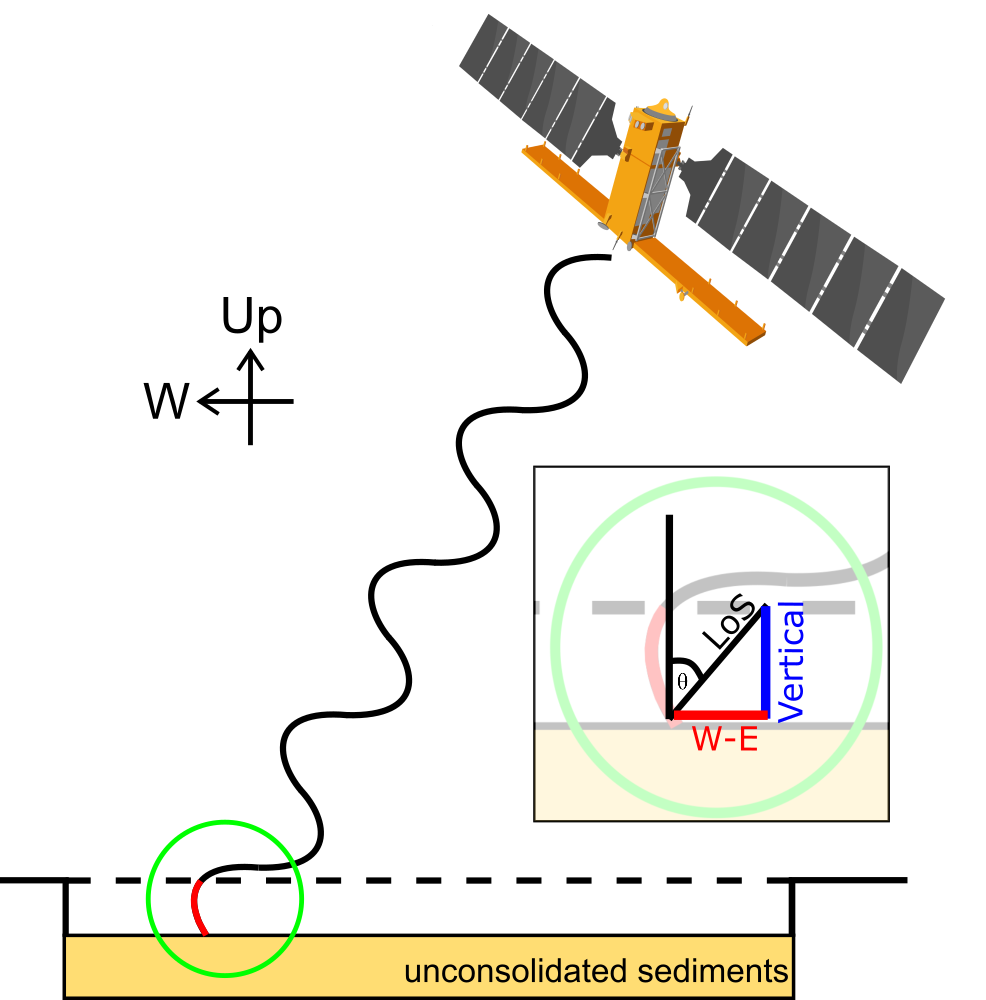
In which direction is the Portal InSAR data measured?
InSAR displacements and velocities presented in this portal are measured solely along the radar line-of-site (LoS) direction of Sentinel-1 satellites. Line-of-site measurements can be decomposed into vertical (up-down) and horizontal (east-west, north-south) component measurements using inverse modelling (see LiCSBAS github, Morishita et al., 2020).
چگونه برداشت آب های زیرزمینی می تواند منجر به فرونشست سطح زمین شود؟
فرونشست سطح زمین می تواند به دلیل پمپاژ آب زیرزمینی از رسوبات قابل تراکم رخ دهد (Gambolati & Teatini, 2015). کل بار ژئواستاتیک روی آبخوان و بسترهای محصور تا حدی توسط فشار منفذی درون رسوب متعادل می شود. هنگامی که آب زیرزمینی از سفره های زیرزمینی با پمپاژ چاه استخراج می شود، سطح آب ساکن در سفره پایین می آید و فشار منفذی کاهش می یابد. فشار منفذی دیگر نمی تواند درصد زیادی از بار ژئواستاتیک را تحمل کند. بار اضافی به تماس های دانه به دانه رسوب منتقل می شود و باعث انتقال تنش از سیال به فاز جامد می شود. تنش موثر افزایش می یابد و باعث فشرده شدن آبخوان و لایه های مجاور می شود. تراکم تجمعی لایه های زیرسطحی به سطح زمین منتقل می شود که در نتیجه فروکش می کند.
GACOS چیست؟
GACOS مدل اصلاح جوی عمومی برای مشاهدات رادار دیافراگم مصنوعی تداخل سنجی است (یو و همکاران، 2018). جو می تواند باعث ایجاد نویز در داده های InSAR شود که به طور کامل سیگنال های تغییر شکل در داده های InSAR را پنهان می کند. بنابراین ابزار GACOS برای «تصحیح» یا حذف مؤثر نویز جوی (تروپوسفر) از داده های InSAR توسعه داده شد.
در پورتال، می توانید انتخاب کنید که داده ها را با اعمال تصحیح GACOS مشاهده کنید ("تصحیح"). بنابراین، تأثیر تصحیح GACOS و نویز اتمسفر بر داده های سری زمانی Sentinel-1 InSAR در مناطق فرونشسته قابل مشاهده است.
فیلتر فضایی و زمانی چیست؟
داده های سری زمانی InSAR می تواند شامل نویزهای دیگری غیر از نویز جوی (تروپوسفر) از جمله نویز ناشی از یونوسفر و خطاهای مداری باشد. برای حذف این نویز می توان از فیلترهای فضایی و زمانی استفاده کرد. این فیلتر در زمان بالا گذر و در فضا کم گذر با هسته گاوسی یک بعدی و دو بعدی در زمان و مکان است (موریشیتا و همکاران، 2020).
در پورتال، می توانید انتخاب کنید که داده ها را با فیلتر مکانی-زمانی اعمال شده ("فیلتر شده") مشاهده کنید. بنابراین، تأثیر فیلتر بر روی داده های سری زمانی Sentinel-1 InSAR مناطق در حال فرونشست قابل مشاهده است.
داده های Portal InSAR در کدام جهت اندازه گیری می شود؟
جابجایی ها و سرعت های InSAR ارائه شده در این پورتال صرفاً در امتداد جهت رادار خط محل (LOS) ماهواره های Sentinel-1 اندازه گیری می شوند. اندازه گیری های خط محل را می توان با استفاده از مدل سازی معکوس به اندازه گیری های عمودی (بالا به پایین) و افقی (شرق-غرب، شمال-جنوب) تجزیه کرد (به LiCSBAS github، موریشیتا و همکاران، 2020 مراجعه کنید).
LiCSAR Data
Interferograms and coherence maps have been produced automatically using the Looking Into Continents from Space with Synthetic Aperture Radar (LiCSAR) processor, which builds on the GAMMA SAR and Interferometry software. Interferograms have been processed in overlapping “frames” defined within COMET-LiCS (Lazecky et al., 2020).
LiCSAR contains modified Copernicus Sentinel data analysed by the Centre for the Observation and Modelling of Earthquakes, Volcanoes and Tectonics (COMET). LiCSAR uses JASMIN, the UK’s collaborative data analysis environment (Lawrence et al., 2013, https://jasmin.ac.uk).
Time-series data are produced using the LiCSBAS Automatic InSAR Time Series Analysis package (Morishita et al., 2020) which integrates with LiCSAR. The portal will always have the latest processed results. New time-series data should be available within 2-3 weeks of acquisition.
Citations
Please include the following acknowledgement and citations when using COMET LiCS Land Subsidence Portal data:
Payne, J. Watson, A. Thomas, M. Crowley, K. Maghsoudi, Y. Lazecky, M. Rigby, R. Ebmeier, S. and Elliott, J. 2022. Nation-wide characterisation of actively subsiding basins in Iran using 7 years of Sentinel-1 InSAR time series analysis, Living Planet Symposium, 2022.
Data quality
Please note that data on this portal and information relating to this portal are currently unpublished. We will publish in future. Data has not been verified or compared with any independent datasets. You may quality control the data yourself by comparing the closeness of ascending and descending data for the same location.
داده های LiCSAR
این سامانه تداخل نماها و داده های کوهرنس را به طور خودکار با استفاده از سامانه (LiCSAR) که بر اساس نرم افزار GAMMA SAR و اتداخل سنجی ساخته شده است، تولید می کند. تداخل نماها در فریم های همپوشانی که در COMET-LiCS تعریف شده اند پردازش شده اند (Lazecky et al., 2020).
سامانه LiCSAR توسط مرکز مشاهده و مدل سازی زمین لرزه ها، آتشفشان ها و زمین ساخت (COMET) تحلیل شده است. LiCSAR از JASMIN، محیط تجزیه و تحلیل داده های مشترک بریتانیا استفاده می کند (لارنس و همکاران، 2013، https://jasmin.ac.uk).
داده های سری زمانی با استفاده از نرم افزار تحلیل سری زمانی لیکسبس تولید می شوند که با LiCSAR ادغام می شود.
پورتال همیشه آخرین نتایج پردازش شده را خواهد داشت. داده های سری زمانی جدید باید ظرف 2 تا 3 هفته پس از کسب در دسترس باشند.
استناد
لطفاً هنگام استفاده از داده های پورتال فرونشست زمین COMET LiCS، به موارد زیر رفرنس دهید:
Payne, J. Watson, A. Thomas, M. Crowley, K. Maghsoudi, Y. Lazecky, M. Rigby, R. Ebmeier, S. and Elliott, J. 2022. Nation-wide characterisation of actively subsiding basins in Iran using 7 years of Sentinel-1 InSAR time series analysis, Living Planet Symposium, 2022.
کیفیت داده
لطفاً توجه داشته باشید که داده های موجود در این پورتال و کلیه اطلاعات مربوطه در حال حاضر در جایی منتشر نشده اند و در آینده منتشر خواهند شد. لازم به ذکر است این محصولات با هیچ مجموعه داده واقعیت زمینی مقایسه نشده اند. برای کنترل کیفیت نتایج میتوانید اقدام به مقایسه دادههای بالا گذر و پایین گذر برای یک مکان مشخص نمایید
Text references
Amighpey, M., S. Arabi, (2016), Studying land subsidence in Yazd province Iran, by integration of InSAR and levelling measurements, Remote Sensing Applications: Society and Environment, 4, 1-8, doi: 10.1016/j.rsase.2016.04.001.
Babaee, S., Z. Mousavi, Z. Masoumi, A. H. Malekshah, M. Roostaei, M. Aflaki (2019), Land subsidence from interfometric SAR and groundwater patterns in the Qazvin plain, Iran, International Journal of Remote Sensing, 41 (12), 4780-4798, doi: 10.1080/01431161.2020.1724345.
Chaussard, E., F. Amelung, H. Abidin, and S.-H. Hong (2013), Sinking cities in Indonesia: ALOS PALSAR detects rapid subsidence due to groundwater and gas extraction, Remote Sensing of Environment, 128, 150–161, doi: 10.1016/j.rse.2012.10.015.
Dehghani, M., M. J. Valadan Zoej, A. Hooper, R. F. Hanssen, I. Entezam, and S. Saatchi (2013), Hybrid conventional and Persistent Scatterer SAR interferometry for land subsidence monitoring in the Tehran Basin, Iran, ISPRS Journal of Photogrammetry and Remote Sensing, 79, 157–170, doi: 10.1016/j.isprsjprs.2013.02.012.
Foroughnia, F., Nemati, N., Maghsoudi, Y. and Perissin, D. An Iterative PS-InSAR Method for the Analysis of Large Spatio-Temporal Baseline Data Stacks for Land Subsidence Estimation. International Journal of Applied Earth Observation and Geoinformation, 2019, Volume 74, Pages 248-258 doi: 10.1016/j.jag.2018.09.018.
Gambolati, G., and P. Teatini (2015), Geomechanics of subsurface water withdrawal and injection, Water Resources Research, 51 (6), 3922–3955, doi: 10.1002/2014WR016841.
Goorabi, A., M., Karimi, M. Yamani, D. Perissin (2020), Land subsidence in Isfahan metropolitan and its relationship with geological and geomorphological settings revealed by Sentinel-1A InSAR observations, Jounral of Arid Environments, 181, 104238, doi: 10.1016/j.jaridenv.2020.104238.
Khorrami, M., Abrishami, S., Maghsoudi, Y., Alizadeh, B. & Perissin, D.: Extreme subsidence in a populated city (Mashhad) detected by PSInSAR considering groundwater withdrawal and geotechnical properties. Nature Sci Rep 10, 11357 (2020), doi: 10.1038/s41598-020-67989-1.
Khoshlahjeh Azar, M.; Hamedpour, A.; Maghsoudi, Y.; Perissin, D. Analysis of the Deformation Behavior and Sinkhole Risk in Kerdabad, Iran Using the PS-InSAR Method. Remote Sens. 2021, 13, 2696, doi: 10.3390/rs13142696.
Lawrence, B. N., V. L. Bennett, J. Churchill, M. Juckes, P. Kershaw, S. Pascoe, S. Pepler, M. Pritchard, and A. Stephens (2013), Storing and manipulating environmental big data with JASMIN, in 2013 IEEE International Conference on Big Data, pp. 68–75, doi: 10.1109/BigData.2013.6691556.
Lazecký, M., Spaans, K. González, P.J. Maghsoudi, Y. Morishita, Y. Albino, F. Elliott, J. Greenall, N. Hatton, E.L. Hooper, A. Juncu, D. McDougall, A. Walters, R.J. Watson, C. Weiss, J.R. and Wright, T. (2020), LiCSAR: An Automatic InSAR Tool for Measuring and Monitoring Tectonic and Volcanic Activity, Remote Sensing, 12 (15), 2430, doi: 10.3390/rs12152430.
Javad Mirzadeh, S. M. J., S. Jin, E. Parizi, E. Chaussard, R. Bürgmann, J. M. Delgado Blasco, M. Amani, H. Bao, and S. H. Mirzadeh (2021), Characterization of Irreversible Land Subsidence in the Yazd-Ardakan Plain, Iran From 2003 to 2020 InSAR Time Series, Journal of Geophysical Research: Solid Earth, 126 (11), doi: 10.1029/2021JB022258.
Motagh, M., T. R. Walter, M. A. Sharifi, E. Fielding, A. Schenk, J. Anderssohn, and J. Zschau (2008), Land subsidence in Iran caused by widespread water reservoir overexploitation, Geophysical Research Letters, 35 (16), doi: 10.1029/2008GL033814.
Morishita, Y., M. Lazecky, T. J. Wright, J. R. Weiss, J. R. Elliott, and A. Hooper (2020), LiCSBAS: An Open-Source InSAR Time Series Analysis Package Integrated with the LiCSAR Automated Sentinel- 1 InSAR Processor, Remote Sensing, 12 (3), 424, doi: 10.3390/rs12030424.
Olen, S. M. (2021), Water bankruptcy in Iran, Nature Sustainability, 4 (11), doi: 10.1038/s41893-021-00763-x.
Yu, C., Z., Li, N. T. Penna, P. Crippa (2018), General Atmospheric Correction Model for Interferometric Synthetic Aperture Radar Observations, 123 (10), 9202-9222, doi: 10.1029/2017JB015305.